Lubudi Mining Permit 13628 — ML-Driven Mineral Exploration Analysis
📍 Lualaba Province, Democratic Republic of the Congo📐 1,353.86 ha🪨 Copper (Cu) · Cobalt (Co) · Polymetallic (U-Zn-Ag)📅 30 April 2026🔖 SP-2026-LB-001
72Drill Targets
13 critical · 12 high
1,354Hectares
13.54 km²
72In Permit
point-in-polygon verified
CobaltDominant
commodity signal
12Spectral Indices
Sentinel-2 L2A
6ML Methods
ensemble consensus
1. Executive Summary
Strataprobe has completed a comprehensive ML-driven mineral exploration analysis of the Lubudi Mining Permit 13628 — a 1,353.86 ha (13.54 km²) concession in Lualaba Province, Democratic Republic of the Congo. The permit lies within the Central African Copperbelt — the world's largest sediment-hosted Cu-Co province, hosting roughly 10% of global Cu reserves and over 50% of global Co reserves — in the Katanga Supergroup of the Lufilian Arc fold-thrust belt.
Using cloud-free Sentinel-2 satellite scenes from the 2024 dry season, we extracted 12 spectral indices at 10–20 m spatial resolution and processed them through a six-method ML pipeline comprising PCA/Crosta mineral mapping, Spectral Angle Mapper lithology classification, Isolation Forest anomaly detection, XGBoost refinement, fuzzy logic prospectivity modelling, and structural lineament analysis.
The ensemble consensus identified prospective drill targets confined strictly to the permit boundary. The dominant prospective commodity across the area is Copper, with strongly co-located Cobalt signatures consistent with the Mines Series stratigraphy of the Roan Group. Distinct gossan, clay-alteration, and Fe-Mn oxide responses suggest an oxidised cap over a sulfide-bearing root — the classic exploration target in this district.
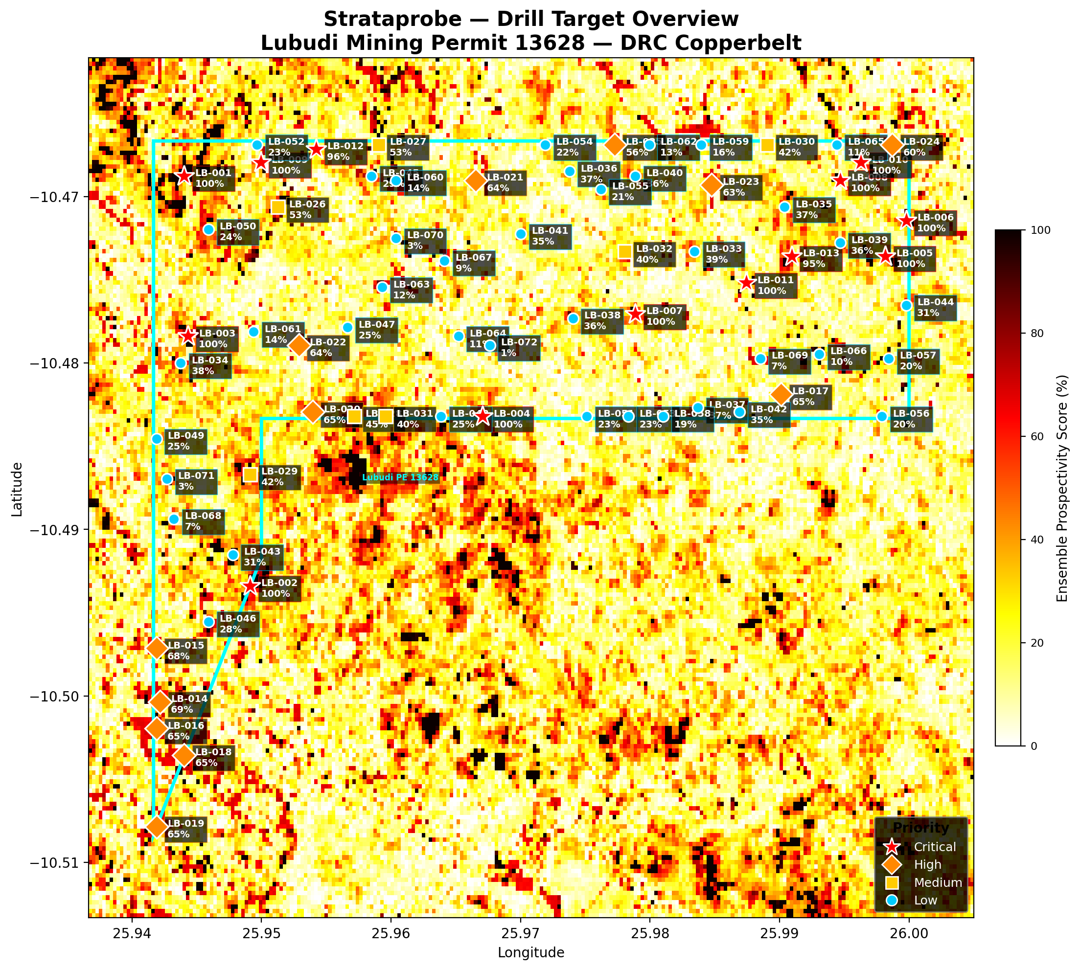
2. Interactive Permit Map — Satellite & Index Overlays
Use the layer control (top-right of the map) to swap between true-colour Sentinel-2, false-colour geology, and any of the 12 mineral-prospectivity indices. The cyan polygon shows the Lubudi PE 13628 boundary. Tap markers for target details.
Critical (≥70%)
High (55–70%)
Medium (40–55%)
Low (<40%)
Permit boundary
Tip: pinch to zoom on mobile. Tap a marker to see the target ID, commodity, score, SAM lithology match and recommended drill depth. Use the opacity slider to see basemap features through the overlay.
85%
3. Geological Setting
The permit lies within the Central African Copperbelt of southern DRC — the world's premier sediment-hosted stratiform Cu-Co province. Mineralisation is hosted in the Neoproterozoic Katanga Supergroup, deformed by the Pan-African Lufilian Arc orogeny. The Copperbelt accounts for the majority of global Cobalt production and a significant share of global Copper output, with deposits typically grading 2–5% Cu and 0.1–0.5% Co.
The stratigraphic succession in this district comprises the Roan Group (R1–R4 — hosting the productive Mines Series including R.A.T., dolomitic shales, siliceous dolomites, and the ore-bearing Black Mineralised Series), the Mwashya Group, the Nguba Group (including the "Grand Conglomérat" diamictite), and the Kundelungu Group. Cu-Co mineralisation occurs predominantly as stratabound disseminations and replacements of carbonaceous, dolomitic siltstones and shales. Primary sulfides are typically weathered in the upper 30–100 m to oxide ore (malachite, chrysocolla, heterogenite), forming the high-grade supergene blankets that dominate current open-pit mining.
At the Lubudi PE 13628 location (centred near 25.97°E, 10.49°S), the area sits along the southern flank of the Lufilian Arc. Surficial expression of mineralisation often includes vivid green malachite staining, black heterogenite crusts in karstic dolomite cavities, and Fe-Mn oxide gossans over sulfide roots. Lateritic weathering profiles can extend 30–120 m below surface, hosting significant Co-bearing oxide ore.
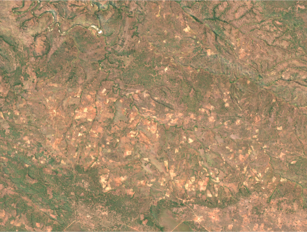
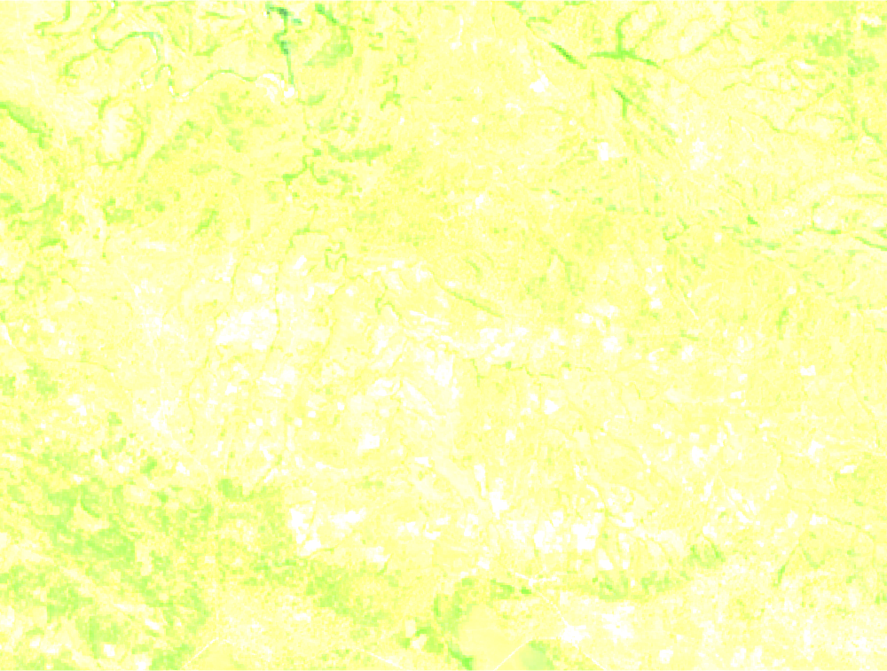
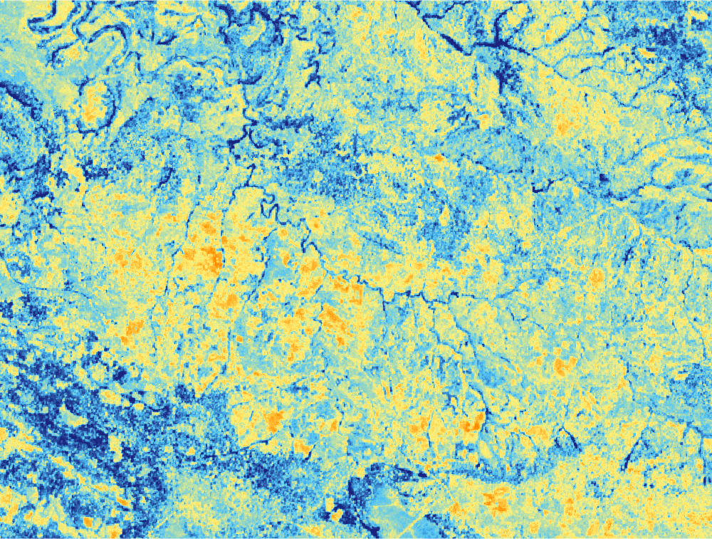
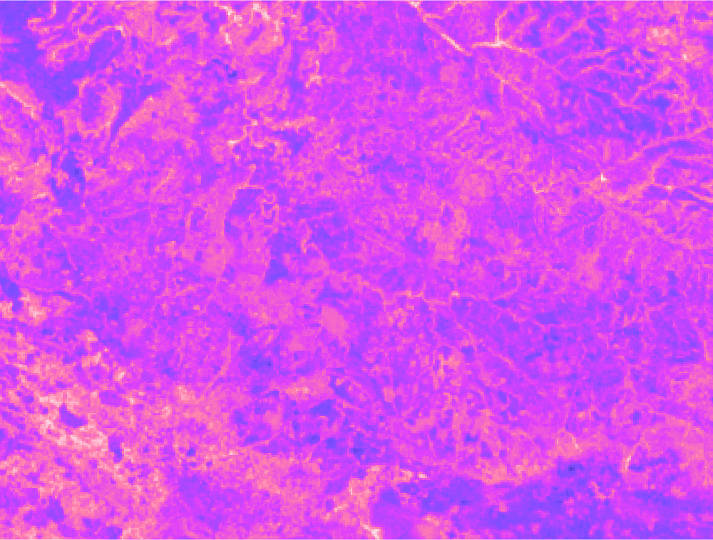
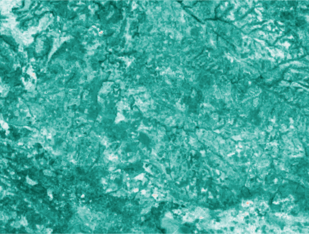
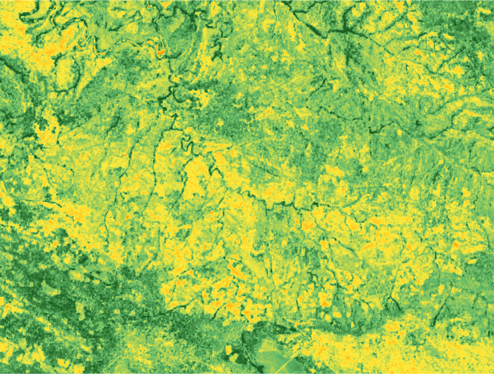
Figure 2 — Sentinel-2 true-colour composite (dry season 2024).Figure 3 — False-colour geology composite (SWIR2/SWIR1/Red). Variations in colour indicate differences in rock composition and alteration intensity.
4. Methodology — 10-Step ML Pipeline
Click each step to expand:
1. Sentinel-2 L2A Composite
Cloud-free dry-season median composite from Google Earth Engine using SCL band cloud/shadow masking. Produces analysis-ready surface reflectance.
2. 12 Spectral Indices
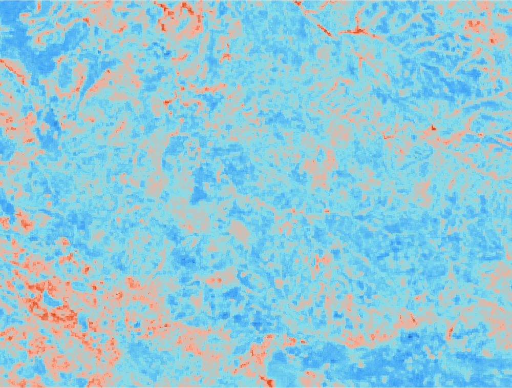
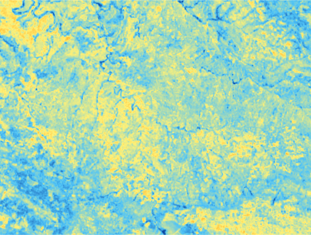
Ferric, Ferrous, Gossan, Laterite, Iron Oxide, Clay/Hydroxyl, Silica, Mafic, Carbonate, NDVI, Moisture, Slope — each tuned to detect specific mineralogical signatures.
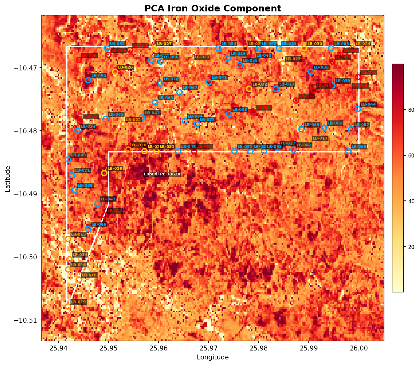
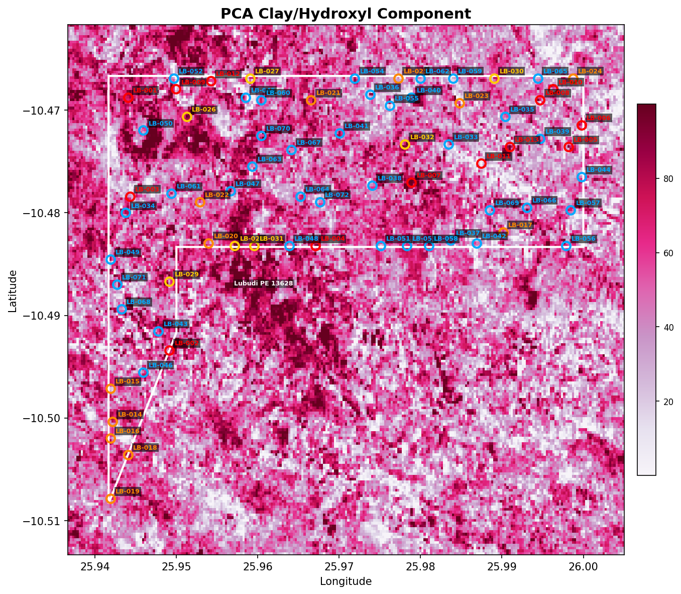
3. PCA / Crosta Method
Principal Component Analysis with Crosta technique to isolate iron-oxide and hydroxyl-mineral feature loadings. The loadings identify which PCs concentrate the alteration signal.
4. Spectral Angle Mapper (SAM)
Cosine distance between each pixel's spectrum and 9 reference Copperbelt endmember spectra (malachite/chrysocolla, heterogenite, Cu-Co gossan, dolomitic shale, Mines Series siltstone, Kundelungu sandstone, lateritic cap, background, vegetation).
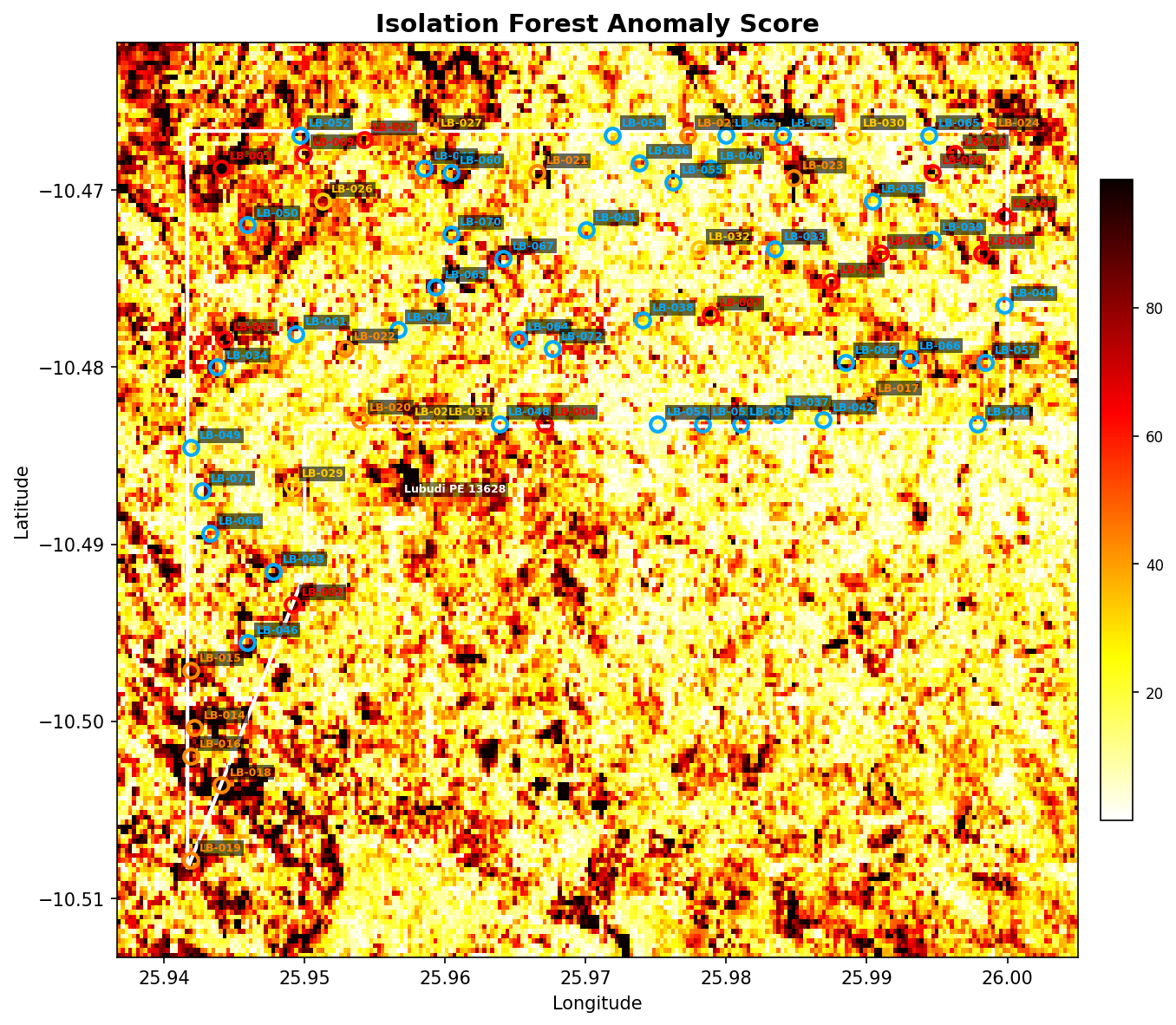
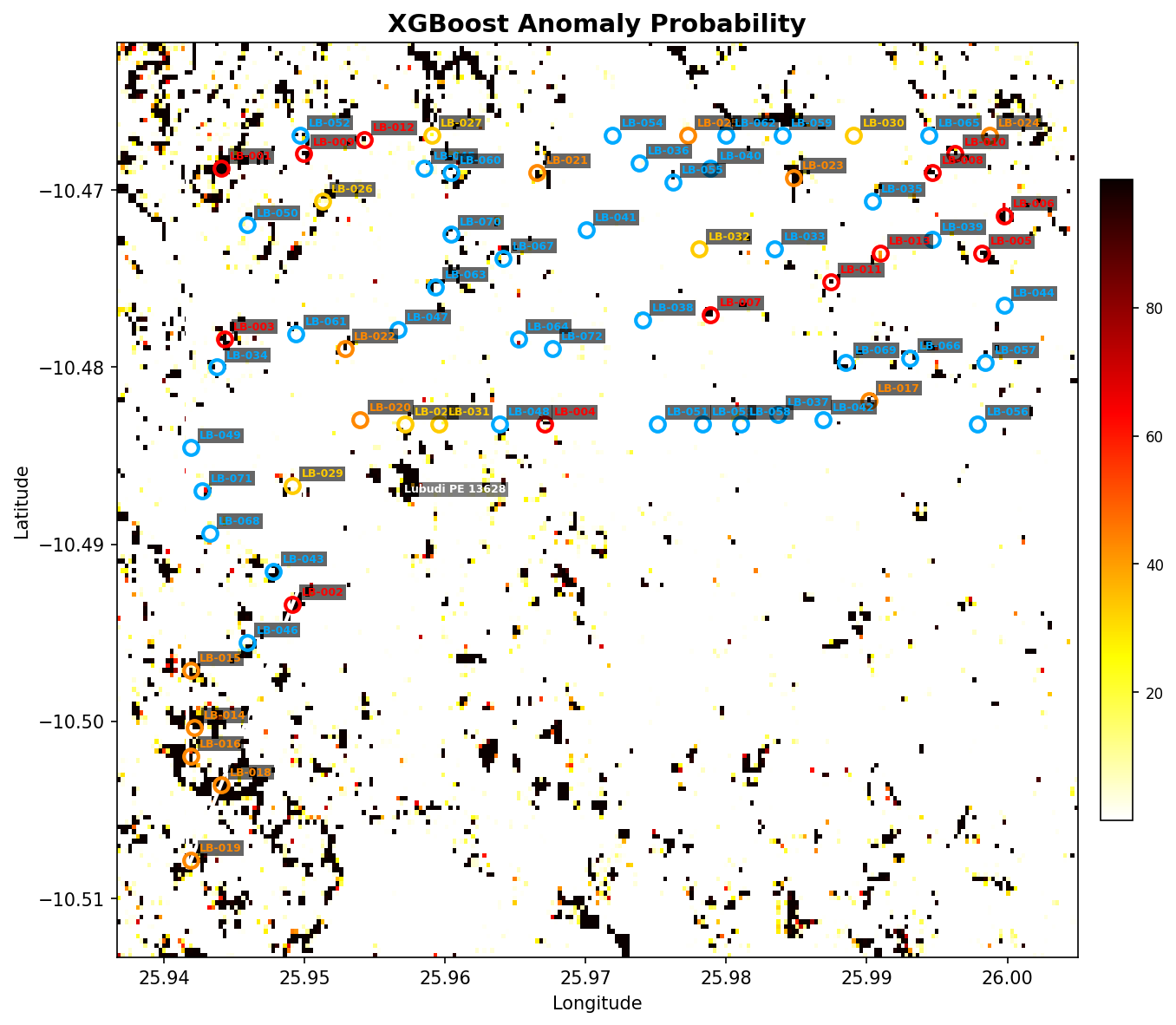
Gradient-boosted classifier trained on Isolation Forest labels, producing sharper anomaly probabilities and feature-importance rankings.
7. Fuzzy Logic Prospectivity
Three commodity-tuned weighted index stacks (Cu, Co, Polymetallic) — geological knowledge encoded as soft logical combinations.
8. Structural Lineament Analysis
Canny edge detection + probabilistic Hough line transform on SRTM slope derivative. Identifies fractures, faults, and lithological contacts that control fluid flow.
9. Ensemble Consensus
Weighted stack: Isolation Forest (20%) + XGBoost (20%) + Fuzzy (20%) + PCA iron (15%) + SAM mineral max (15%) + Lineament density (10%).
10. In-Polygon Target Extraction
Local maxima detection on the ensemble surface within the permit polygon, with strict point-in-polygon verification. Targets ranked by score and assigned Critical/High/Medium/Low priority.
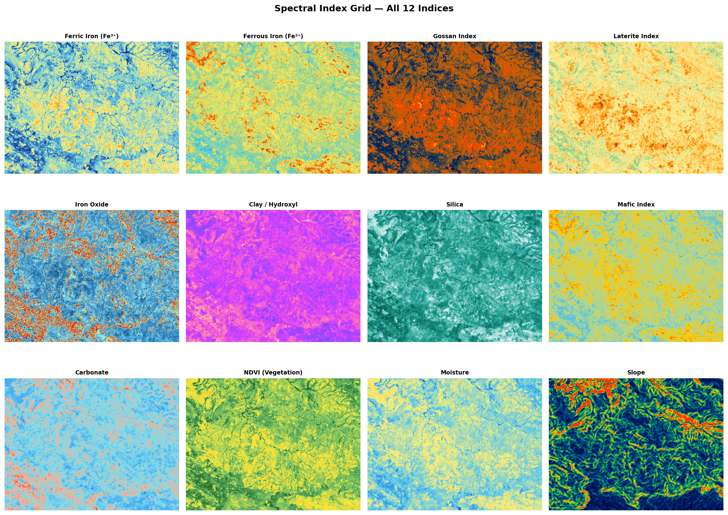
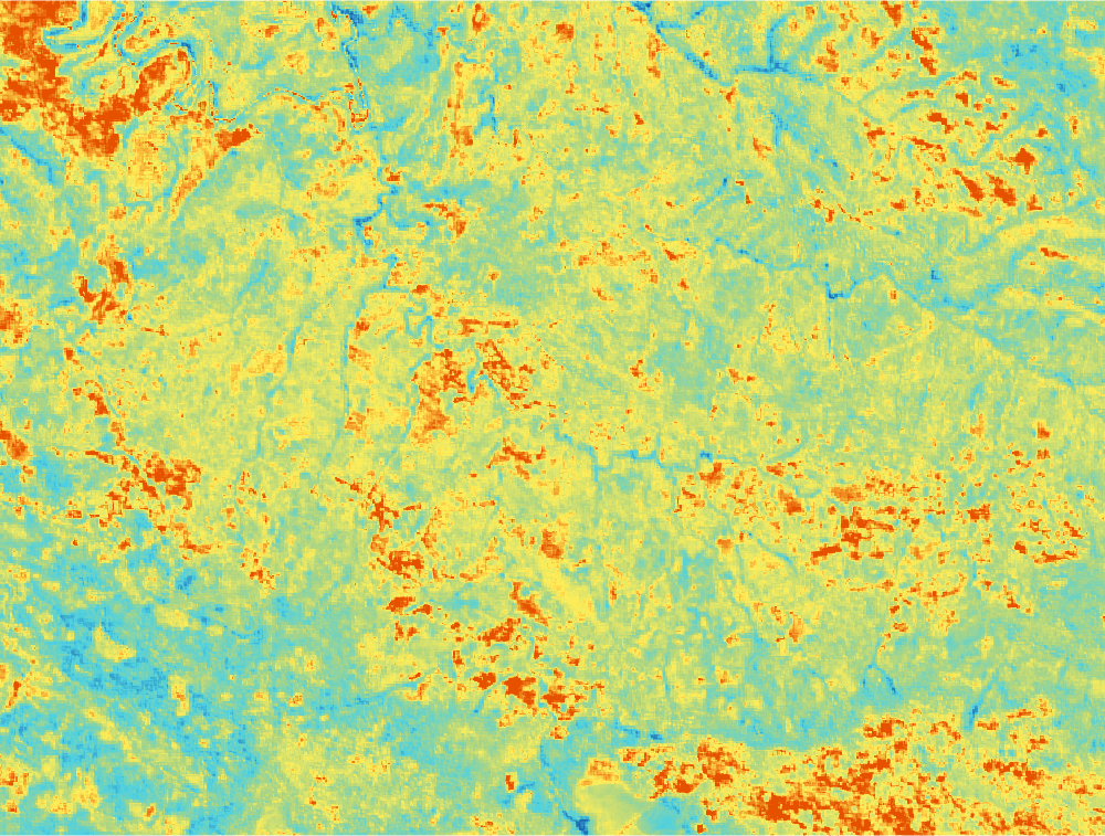
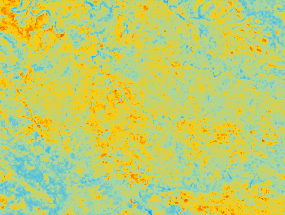
5. Spectral Index Analysis — All 12 Indices
Twelve domain-specific spectral indices were computed at native Sentinel-2 resolution (10–20 m, resampled to a common grid). Each index targets a specific mineralogical or environmental signature relevant to Central African Copperbelt exploration. Tap any index for a full-size view; toggle the matching overlay on the interactive map (Section 2) to see its spatial distribution geo-referenced over the satellite basemap.
Figure 4 — Composite of all 12 spectral index maps over the Lubudi PE 13628 permit. Warm colours (red/orange/yellow) indicate elevated index values; cool colours (blue/green) indicate background.
Index Explorer
Each card explains the formula, the mineralogical sensitivity, and the Copperbelt-specific exploration relevance.
Ferric Iron
B4 / B2 — sensitive to Fe³⁺-bearing oxides (hematite, goethite). High values = oxidised Cu/Fe minerals (a Copperbelt supergene marker).
Ferrous Iron
B11 / B8A — proxy for reduced Fe²⁺ in unweathered sulfides and primary mafic minerals.
Gossan
B4 × B11 / B2 — pinpoints surface oxidation of sulfide bodies. The single highest-value index for Copperbelt sulfide-cap targeting.
Laterite
B11 / B12 — detects Fe-Mn-Al residual lateritic profiles that host supergene Co (heterogenite, asbolane).
Which spectral indices most strongly distinguish anomalous from background pixels?
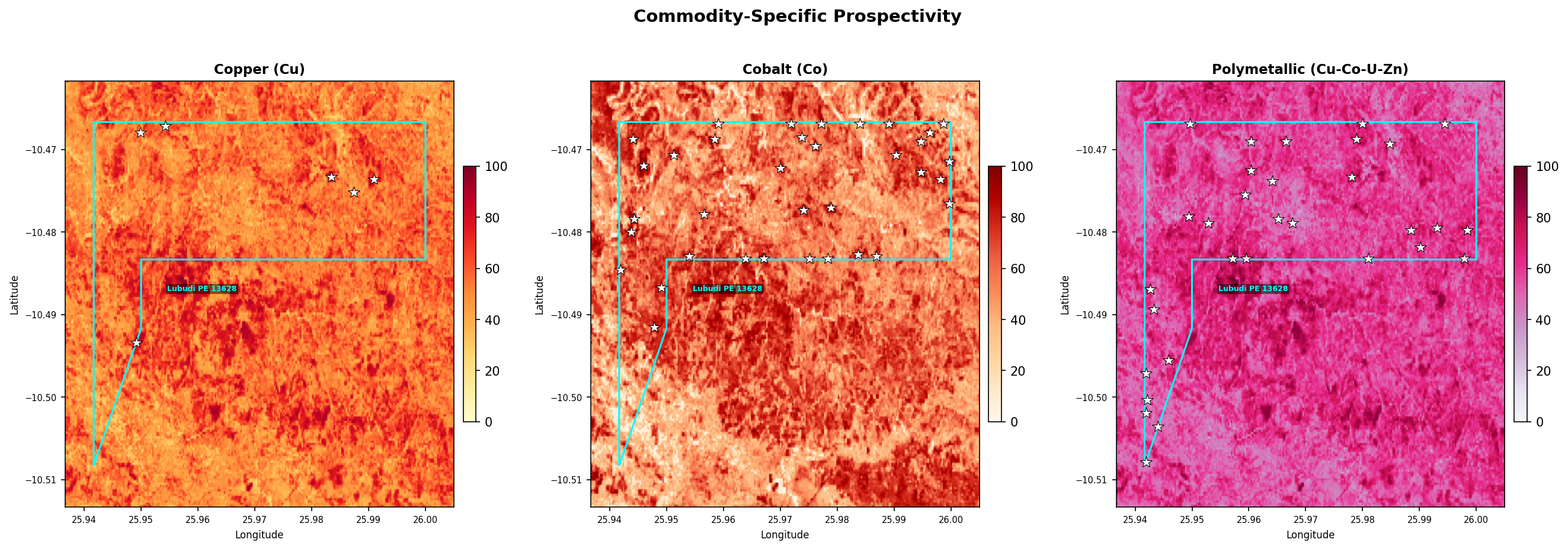
7. Commodity-Specific Prospectivity
Three fuzzy-logic prospectivity models calibrated for Central African Copperbelt mineralisation styles:
Copper (Cu): Weighted toward gossan index (sulfide weathering caps — 25%), ferric iron (oxidised Cu-bearing minerals — 20%), clay/hydroxyl (malachite, chrysocolla, sericitic alteration — 20%), iron oxide (15%), inverse NDVI (10%), and slope (10%). Targets the supergene oxide blanket overlying primary sulfide mineralisation in the Mines Series.
Cobalt (Co): Emphasises iron oxide (Fe-Mn rich heterogenite zones — 25%), ferrous iron (20%), laterite index (Co-bearing oxide laterites — 20%), gossan index (15%), mafic index (10%), and inverse NDVI (10%). Heterogenite (CoOOH) and asbolane develop dark Mn-Fe-oxide crusts in karstic cavities and lateritic profiles.
Polymetallic (Cu-Co-U-Zn-Ag): Focuses on gossan (25%), clay alteration (20%), carbonate (dolomitic host indicator — 15%), silica (15%), ferric iron (10%), inverse NDVI (10%), and slope (10%). Captures the full spectrum of stratiform Cu-Co with associated U, Zn, Pb and Ag commonly enriched in the Copperbelt sediment-hosted system.
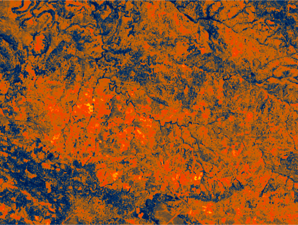
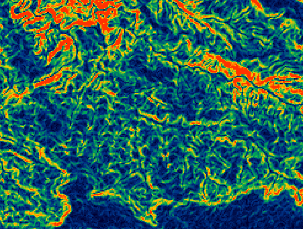
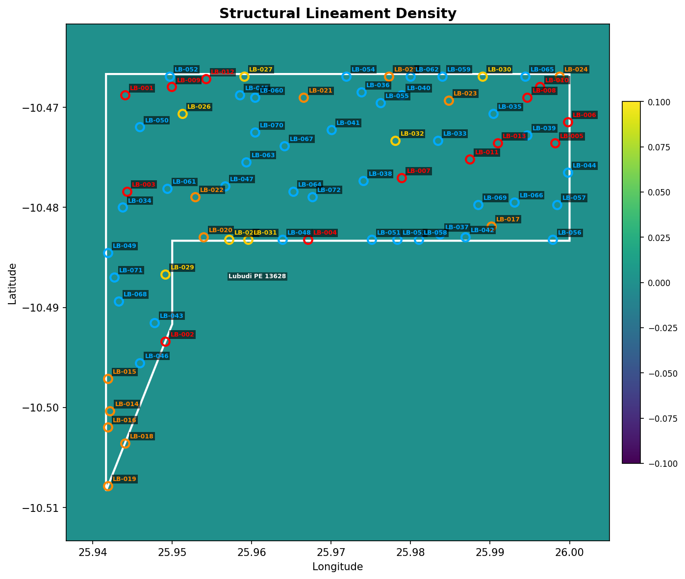
Lineaments were extracted from the SRTM slope derivative using Canny edge detection and probabilistic Hough line transform. Lineaments represent fractures, faults, and lithological contacts that often control fluid flow and ore deposition in the Lufilian Arc fold-thrust belt.
Figure 7 — Lineament density map (Gaussian-smoothed).
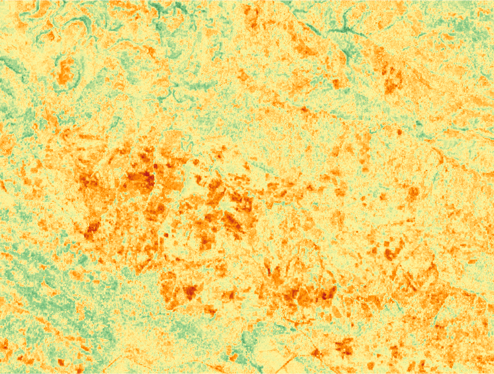
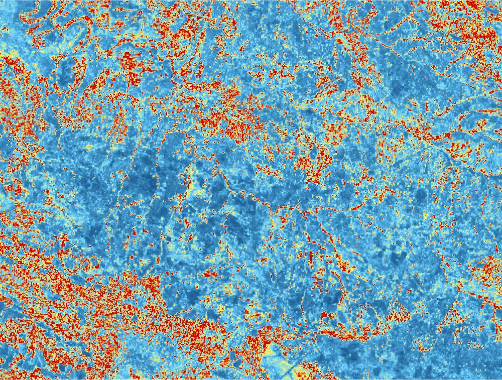
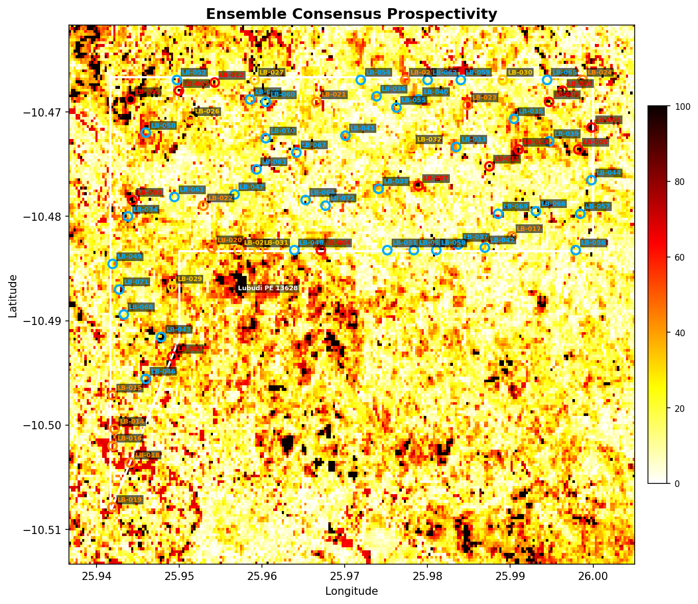
9. Ensemble Consensus & Drill Targets
Figure 8 — Final ensemble consensus map with target markers.
Target Summary Table
ID
Lon
Lat
Score
Commodity
Priority
Depth
SAM Match
Sim%
LB-001
25.94404
10.46876°S
100.0%
Cobalt (Co)
Critical
106–206 m
Heterogenite Co Oxide
71.1%
LB-002
25.94913
10.49339°S
100.0%
Copper (Cu)
Critical
82–182 m
Roan Dolomitic Shale
83.3%
LB-003
25.94430
10.47840°S
100.0%
Cobalt (Co)
Critical
54–154 m
Background Soil
99.5%
LB-004
25.96708
10.48322°S
100.0%
Cobalt (Co)
Critical
73–173 m
Roan Dolomitic Shale
90.3%
LB-005
25.99817
10.47358°S
100.0%
Cobalt (Co)
Critical
56–156 m
Background Soil
95.8%
LB-006
25.99977
10.47144°S
100.0%
Cobalt (Co)
Critical
56–156 m
Background Soil
99.1%
LB-007
25.97887
10.47706°S
100.0%
Cobalt (Co)
Critical
96–196 m
Roan Dolomitic Shale
71.4%
LB-008
25.99468
10.46903°S
100.0%
Cobalt (Co)
Critical
81–181 m
Roan Dolomitic Shale
84.1%
LB-009
25.94993
10.46796°S
100.0%
Copper (Cu)
Critical
66–166 m
Heterogenite Co Oxide
77.1%
LB-010
25.99629
10.46796°S
100.0%
Cobalt (Co)
Critical
54–154 m
Background Soil
98.9%
LB-011
25.98745
10.47519°S
100.0%
Copper (Cu)
Critical
86–186 m
Heterogenite Co Oxide
77.2%
LB-012
25.95422
10.46715°S
95.5%
Copper (Cu)
Critical
120–220 m
Heterogenite Co Oxide
78.0%
LB-013
25.99093
10.47358°S
95.4%
Copper (Cu)
Critical
66–166 m
Roan Dolomitic Shale
95.8%
LB-014
25.94216
10.50035°S
68.7%
Polymetallic (Cu-Co-U-Zn)
High
64–164 m
Background Soil
84.5%
LB-015
25.94189
10.49714°S
68.0%
Polymetallic (Cu-Co-U-Zn)
High
113–213 m
Heterogenite Co Oxide
78.2%
LB-016
25.94189
10.50196°S
65.4%
Polymetallic (Cu-Co-U-Zn)
High
73–173 m
Heterogenite Co Oxide
83.7%
LB-017
25.99013
10.48188°S
65.1%
Polymetallic (Cu-Co-U-Zn)
High
73–173 m
Background Soil
85.6%
LB-018
25.94404
10.50356°S
64.9%
Polymetallic (Cu-Co-U-Zn)
High
77–177 m
Background Soil
80.0%
LB-019
25.94189
10.50784°S
64.7%
Polymetallic (Cu-Co-U-Zn)
High
83–183 m
Heterogenite Co Oxide
82.6%
LB-020
25.95395
10.48295°S
64.7%
Cobalt (Co)
High
79–179 m
Roan Dolomitic Shale
84.9%
LB-021
25.96655
10.46903°S
64.4%
Polymetallic (Cu-Co-U-Zn)
High
83–183 m
Heterogenite Co Oxide
83.2%
LB-022
25.95288
10.47893°S
63.8%
Polymetallic (Cu-Co-U-Zn)
High
87–187 m
Background Soil
73.8%
LB-023
25.98477
10.46930°S
63.1%
Polymetallic (Cu-Co-U-Zn)
High
104–204 m
Heterogenite Co Oxide
68.4%
LB-024
25.99870
10.46689°S
60.2%
Cobalt (Co)
High
73–173 m
Roan Dolomitic Shale
89.8%
LB-025
25.97726
10.46689°S
56.2%
Cobalt (Co)
High
106–206 m
Roan Dolomitic Shale
65.8%
LB-026
25.95127
10.47063°S
53.4%
Cobalt (Co)
Medium
73–173 m
Heterogenite Co Oxide
90.3%
LB-027
25.95904
10.46689°S
53.1%
Cobalt (Co)
Medium
95–195 m
Heterogenite Co Oxide
80.0%
LB-028
25.95717
10.48322°S
45.4%
Polymetallic (Cu-Co-U-Zn)
Medium
81–181 m
Roan Dolomitic Shale
84.5%
LB-029
25.94913
10.48670°S
41.7%
Cobalt (Co)
Medium
56–156 m
Background Soil
98.5%
LB-030
25.98906
10.46689°S
41.5%
Cobalt (Co)
Medium
83–183 m
Roan Dolomitic Shale
81.3%
LB-031
25.95958
10.48322°S
40.2%
Polymetallic (Cu-Co-U-Zn)
Medium
91–191 m
Roan Dolomitic Shale
77.2%
LB-032
25.97807
10.47331°S
40.2%
Polymetallic (Cu-Co-U-Zn)
Medium
68–168 m
Roan Dolomitic Shale
93.6%
LB-033
25.98343
10.47331°S
38.8%
Copper (Cu)
Low
93–193 m
Roan Dolomitic Shale
75.1%
LB-034
25.94377
10.48000°S
37.8%
Cobalt (Co)
Low
60–160 m
Background Soil
95.5%
LB-035
25.99039
10.47063°S
37.3%
Cobalt (Co)
Low
64–164 m
Background Soil
96.4%
LB-036
25.97378
10.46849°S
36.9%
Cobalt (Co)
Low
50–150 m
Background Soil
94.8%
LB-037
25.98370
10.48268°S
36.7%
Cobalt (Co)
Low
69–169 m
Background Soil
93.4%
LB-038
25.97405
10.47733°S
36.3%
Cobalt (Co)
Low
60–160 m
Background Soil
97.3%
LB-039
25.99468
10.47278°S
35.6%
Cobalt (Co)
Low
73–173 m
Background Soil
90.6%
LB-040
25.97887
10.46876°S
35.5%
Polymetallic (Cu-Co-U-Zn)
Low
69–169 m
Background Soil
93.6%
LB-041
25.97003
10.47224°S
35.0%
Cobalt (Co)
Low
82–182 m
Roan Dolomitic Shale
83.4%
LB-042
25.98691
10.48295°S
34.7%
Cobalt (Co)
Low
54–154 m
Background Soil
98.7%
LB-043
25.94779
10.49151°S
30.8%
Cobalt (Co)
Low
64–164 m
Background Soil
92.0%
LB-044
25.99977
10.47652°S
30.7%
Cobalt (Co)
Low
56–156 m
Background Soil
99.1%
LB-045
25.95851
10.46876°S
28.9%
Cobalt (Co)
Low
73–173 m
Background Soil
89.7%
LB-046
25.94591
10.49553°S
27.9%
Polymetallic (Cu-Co-U-Zn)
Low
116–216 m
Heterogenite Co Oxide
68.0%
LB-047
25.95663
10.47786°S
25.4%
Cobalt (Co)
Low
56–156 m
Background Soil
95.6%
LB-048
25.96387
10.48322°S
25.3%
Cobalt (Co)
Low
63–163 m
Heterogenite Co Oxide
78.5%
LB-049
25.94189
10.48456°S
25.2%
Cobalt (Co)
Low
89–189 m
Heterogenite Co Oxide
79.1%
LB-050
25.94591
10.47197°S
23.6%
Cobalt (Co)
Low
120–220 m
Heterogenite Co Oxide
63.1%
LB-051
25.97512
10.48322°S
23.1%
Cobalt (Co)
Low
56–156 m
Background Soil
98.2%
LB-052
25.94966
10.46689°S
23.0%
Polymetallic (Cu-Co-U-Zn)
Low
120–220 m
Heterogenite Co Oxide
61.7%
LB-053
25.97834
10.48322°S
22.6%
Cobalt (Co)
Low
54–154 m
Heterogenite Co Oxide
79.7%
LB-054
25.97190
10.46689°S
22.4%
Cobalt (Co)
Low
76–176 m
Background Soil
88.4%
LB-055
25.97619
10.46956°S
20.7%
Cobalt (Co)
Low
87–187 m
Heterogenite Co Oxide
80.0%
LB-056
25.99790
10.48322°S
20.1%
Polymetallic (Cu-Co-U-Zn)
Low
96–196 m
Heterogenite Co Oxide
75.2%
LB-057
25.99844
10.47974°S
19.5%
Polymetallic (Cu-Co-U-Zn)
Low
96–196 m
Heterogenite Co Oxide
76.1%
LB-058
25.98102
10.48322°S
19.4%
Polymetallic (Cu-Co-U-Zn)
Low
66–166 m
Heterogenite Co Oxide
83.3%
LB-059
25.98396
10.46689°S
16.5%
Cobalt (Co)
Low
78–178 m
Heterogenite Co Oxide
81.4%
LB-060
25.96038
10.46903°S
14.2%
Polymetallic (Cu-Co-U-Zn)
Low
102–202 m
Heterogenite Co Oxide
76.6%
LB-061
25.94940
10.47813°S
13.9%
Polymetallic (Cu-Co-U-Zn)
Low
69–169 m
Background Soil
92.4%
LB-062
25.97995
10.46689°S
12.9%
Polymetallic (Cu-Co-U-Zn)
Low
96–196 m
Roan Dolomitic Shale
73.3%
LB-063
25.95931
10.47545°S
12.4%
Polymetallic (Cu-Co-U-Zn)
Low
89–189 m
Heterogenite Co Oxide
81.6%
LB-064
25.96521
10.47840°S
11.4%
Polymetallic (Cu-Co-U-Zn)
Low
79–179 m
Heterogenite Co Oxide
82.2%
LB-065
25.99442
10.46689°S
10.8%
Polymetallic (Cu-Co-U-Zn)
Low
79–179 m
Heterogenite Co Oxide
86.5%
LB-066
25.99308
10.47947°S
9.9%
Polymetallic (Cu-Co-U-Zn)
Low
120–220 m
Heterogenite Co Oxide
65.1%
LB-067
25.96413
10.47385°S
9.2%
Polymetallic (Cu-Co-U-Zn)
Low
101–201 m
Heterogenite Co Oxide
81.1%
LB-068
25.94323
10.48937°S
7.3%
Polymetallic (Cu-Co-U-Zn)
Low
56–156 m
Heterogenite Co Oxide
81.6%
LB-069
25.98852
10.47974°S
7.3%
Polymetallic (Cu-Co-U-Zn)
Low
74–174 m
Heterogenite Co Oxide
87.0%
LB-070
25.96038
10.47251°S
3.4%
Polymetallic (Cu-Co-U-Zn)
Low
66–166 m
Heterogenite Co Oxide
86.7%
LB-071
25.94270
10.48696°S
2.6%
Polymetallic (Cu-Co-U-Zn)
Low
66–166 m
Background Soil
92.0%
LB-072
25.96762
10.47893°S
1.4%
Polymetallic (Cu-Co-U-Zn)
Low
73–173 m
Heterogenite Co Oxide
89.2%
Per-Target Detail Cards
LB-001Cobalt (Co)
Critical
Longitude
25.944036°E
Latitude
10.468761°S
Ensemble Score
100.0%
Cu Score
57.6%
Co Score
81.2%
Polymetallic Score
63.2%
SAM Best Match
Heterogenite Co Oxide
SAM Similarity
71.1%
Est. Drill Depth
106–206 m
Drill Azimuth
20°
Drill Dip
-60°
Permit
Lubudi PE 13628
LB-002Copper (Cu)
Critical
Longitude
25.949128°E
Latitude
10.493389°S
Ensemble Score
100.0%
Cu Score
87.9%
Co Score
79.9%
Polymetallic Score
87.3%
SAM Best Match
Roan Dolomitic Shale
SAM Similarity
83.3%
Est. Drill Depth
82–182 m
Drill Azimuth
20°
Drill Dip
-60°
Permit
Lubudi PE 13628
LB-003Cobalt (Co)
Critical
Longitude
25.944304°E
Latitude
10.478398°S
Ensemble Score
100.0%
Cu Score
63.4%
Co Score
96.5%
Polymetallic Score
64.5%
SAM Best Match
Background Soil
SAM Similarity
99.5%
Est. Drill Depth
54–154 m
Drill Azimuth
20°
Drill Dip
-60°
Permit
Lubudi PE 13628
LB-004Cobalt (Co)
Critical
Longitude
25.967082°E
Latitude
10.483217°S
Ensemble Score
100.0%
Cu Score
85.5%
Co Score
89.0%
Polymetallic Score
84.6%
SAM Best Match
Roan Dolomitic Shale
SAM Similarity
90.3%
Est. Drill Depth
73–173 m
Drill Azimuth
20°
Drill Dip
-60°
Permit
Lubudi PE 13628
LB-005Cobalt (Co)
Critical
Longitude
25.998167°E
Latitude
10.473580°S
Ensemble Score
100.0%
Cu Score
47.2%
Co Score
82.3%
Polymetallic Score
52.8%
SAM Best Match
Background Soil
SAM Similarity
95.8%
Est. Drill Depth
56–156 m
Drill Azimuth
20°
Drill Dip
-60°
Permit
Lubudi PE 13628
LB-006Cobalt (Co)
Critical
Longitude
25.999775°E
Latitude
10.471438°S
Ensemble Score
100.0%
Cu Score
60.6%
Co Score
92.3%
Polymetallic Score
62.7%
SAM Best Match
Background Soil
SAM Similarity
99.1%
Est. Drill Depth
56–156 m
Drill Azimuth
20°
Drill Dip
-60°
Permit
Lubudi PE 13628
LB-007Cobalt (Co)
Critical
Longitude
25.978873°E
Latitude
10.477060°S
Ensemble Score
100.0%
Cu Score
88.1%
Co Score
93.0%
Polymetallic Score
87.2%
SAM Best Match
Roan Dolomitic Shale
SAM Similarity
71.4%
Est. Drill Depth
96–196 m
Drill Azimuth
20°
Drill Dip
-60°
Permit
Lubudi PE 13628
LB-008Cobalt (Co)
Critical
Longitude
25.994683°E
Latitude
10.469029°S
Ensemble Score
100.0%
Cu Score
69.7%
Co Score
95.0%
Polymetallic Score
70.7%
SAM Best Match
Roan Dolomitic Shale
SAM Similarity
84.1%
Est. Drill Depth
81–181 m
Drill Azimuth
20°
Drill Dip
-60°
Permit
Lubudi PE 13628
LB-009Copper (Cu)
Critical
Longitude
25.949932°E
Latitude
10.467958°S
Ensemble Score
100.0%
Cu Score
45.3%
Co Score
40.8%
Polymetallic Score
42.8%
SAM Best Match
Heterogenite Co Oxide
SAM Similarity
77.1%
Est. Drill Depth
66–166 m
Drill Azimuth
20°
Drill Dip
-60°
Permit
Lubudi PE 13628
LB-010Cobalt (Co)
Critical
Longitude
25.996291°E
Latitude
10.467958°S
Ensemble Score
100.0%
Cu Score
58.6%
Co Score
90.1%
Polymetallic Score
61.2%
SAM Best Match
Background Soil
SAM Similarity
98.9%
Est. Drill Depth
54–154 m
Drill Azimuth
20°
Drill Dip
-60°
Permit
Lubudi PE 13628
LB-011Copper (Cu)
Critical
Longitude
25.987448°E
Latitude
10.475186°S
Ensemble Score
100.0%
Cu Score
42.5%
Co Score
39.6%
Polymetallic Score
39.8%
SAM Best Match
Heterogenite Co Oxide
SAM Similarity
77.2%
Est. Drill Depth
86–186 m
Drill Azimuth
20°
Drill Dip
-60°
Permit
Lubudi PE 13628
LB-012Copper (Cu)
Critical
Longitude
25.954219°E
Latitude
10.467155°S
Ensemble Score
95.5%
Cu Score
57.0%
Co Score
48.8%
Polymetallic Score
56.3%
SAM Best Match
Heterogenite Co Oxide
SAM Similarity
78.0%
Est. Drill Depth
120–220 m
Drill Azimuth
20°
Drill Dip
-60°
Permit
Lubudi PE 13628
LB-013Copper (Cu)
Critical
Longitude
25.990931°E
Latitude
10.473580°S
Ensemble Score
95.4%
Cu Score
86.4%
Co Score
83.3%
Polymetallic Score
86.0%
SAM Best Match
Roan Dolomitic Shale
SAM Similarity
95.8%
Est. Drill Depth
66–166 m
Drill Azimuth
20°
Drill Dip
-60°
Permit
Lubudi PE 13628
LB-014Polymetallic (Cu-Co-U-Zn)
High
Longitude
25.942160°E
Latitude
10.500350°S
Ensemble Score
68.7%
Cu Score
31.9%
Co Score
10.4%
Polymetallic Score
44.7%
SAM Best Match
Background Soil
SAM Similarity
84.5%
Est. Drill Depth
64–164 m
Drill Azimuth
20°
Drill Dip
-60°
Permit
Lubudi PE 13628
LB-015Polymetallic (Cu-Co-U-Zn)
High
Longitude
25.941892°E
Latitude
10.497137°S
Ensemble Score
68.0%
Cu Score
41.4%
Co Score
15.4%
Polymetallic Score
50.9%
SAM Best Match
Heterogenite Co Oxide
SAM Similarity
78.2%
Est. Drill Depth
113–213 m
Drill Azimuth
20°
Drill Dip
-60°
Permit
Lubudi PE 13628
LB-016Polymetallic (Cu-Co-U-Zn)
High
Longitude
25.941892°E
Latitude
10.501956°S
Ensemble Score
65.4%
Cu Score
35.8%
Co Score
14.3%
Polymetallic Score
46.6%
SAM Best Match
Heterogenite Co Oxide
SAM Similarity
83.7%
Est. Drill Depth
73–173 m
Drill Azimuth
20°
Drill Dip
-60°
Permit
Lubudi PE 13628
LB-017Polymetallic (Cu-Co-U-Zn)
High
Longitude
25.990128°E
Latitude
10.481878°S
Ensemble Score
65.1%
Cu Score
30.7%
Co Score
5.5%
Polymetallic Score
46.5%
SAM Best Match
Background Soil
SAM Similarity
85.6%
Est. Drill Depth
73–173 m
Drill Azimuth
20°
Drill Dip
-60°
Permit
Lubudi PE 13628
LB-018Polymetallic (Cu-Co-U-Zn)
High
Longitude
25.944036°E
Latitude
10.503562°S
Ensemble Score
64.9%
Cu Score
29.4%
Co Score
1.3%
Polymetallic Score
47.3%
SAM Best Match
Background Soil
SAM Similarity
80.0%
Est. Drill Depth
77–177 m
Drill Azimuth
20°
Drill Dip
-60°
Permit
Lubudi PE 13628
LB-019Polymetallic (Cu-Co-U-Zn)
High
Longitude
25.941892°E
Latitude
10.507845°S
Ensemble Score
64.7%
Cu Score
34.7%
Co Score
8.3%
Polymetallic Score
48.7%
SAM Best Match
Heterogenite Co Oxide
SAM Similarity
82.6%
Est. Drill Depth
83–183 m
Drill Azimuth
20°
Drill Dip
-60°
Permit
Lubudi PE 13628
LB-020Cobalt (Co)
High
Longitude
25.953951°E
Latitude
10.482949°S
Ensemble Score
64.7%
Cu Score
79.0%
Co Score
87.6%
Polymetallic Score
78.0%
SAM Best Match
Roan Dolomitic Shale
SAM Similarity
84.9%
Est. Drill Depth
79–179 m
Drill Azimuth
20°
Drill Dip
-60°
Permit
Lubudi PE 13628
LB-021Polymetallic (Cu-Co-U-Zn)
High
Longitude
25.966546°E
Latitude
10.469029°S
Ensemble Score
64.4%
Cu Score
36.2%
Co Score
11.3%
Polymetallic Score
48.6%
SAM Best Match
Heterogenite Co Oxide
SAM Similarity
83.2%
Est. Drill Depth
83–183 m
Drill Azimuth
20°
Drill Dip
-60°
Permit
Lubudi PE 13628
LB-022Polymetallic (Cu-Co-U-Zn)
High
Longitude
25.952879°E
Latitude
10.478934°S
Ensemble Score
63.8%
Cu Score
31.8%
Co Score
1.8%
Polymetallic Score
49.4%
SAM Best Match
Background Soil
SAM Similarity
73.8%
Est. Drill Depth
87–187 m
Drill Azimuth
20°
Drill Dip
-60°
Permit
Lubudi PE 13628
LB-023Polymetallic (Cu-Co-U-Zn)
High
Longitude
25.984768°E
Latitude
10.469296°S
Ensemble Score
63.1%
Cu Score
36.6%
Co Score
3.8%
Polymetallic Score
53.1%
SAM Best Match
Heterogenite Co Oxide
SAM Similarity
68.4%
Est. Drill Depth
104–204 m
Drill Azimuth
20°
Drill Dip
-60°
Permit
Lubudi PE 13628
LB-024Cobalt (Co)
High
Longitude
25.998703°E
Latitude
10.466887°S
Ensemble Score
60.2%
Cu Score
69.5%
Co Score
92.3%
Polymetallic Score
70.0%
SAM Best Match
Roan Dolomitic Shale
SAM Similarity
89.8%
Est. Drill Depth
73–173 m
Drill Azimuth
20°
Drill Dip
-60°
Permit
Lubudi PE 13628
LB-025Cobalt (Co)
High
Longitude
25.977265°E
Latitude
10.466887°S
Ensemble Score
56.2%
Cu Score
83.5%
Co Score
87.7%
Polymetallic Score
82.7%
SAM Best Match
Roan Dolomitic Shale
SAM Similarity
65.8%
Est. Drill Depth
106–206 m
Drill Azimuth
20°
Drill Dip
-60°
Permit
Lubudi PE 13628
LB-026Cobalt (Co)
Medium
Longitude
25.951272°E
Latitude
10.470635°S
Ensemble Score
53.4%
Cu Score
48.8%
Co Score
86.2%
Polymetallic Score
54.7%
SAM Best Match
Heterogenite Co Oxide
SAM Similarity
90.3%
Est. Drill Depth
73–173 m
Drill Azimuth
20°
Drill Dip
-60°
Permit
Lubudi PE 13628
LB-027Cobalt (Co)
Medium
Longitude
25.959043°E
Latitude
10.466887°S
Ensemble Score
53.1%
Cu Score
49.7%
Co Score
62.0%
Polymetallic Score
46.9%
SAM Best Match
Heterogenite Co Oxide
SAM Similarity
80.0%
Est. Drill Depth
95–195 m
Drill Azimuth
20°
Drill Dip
-60°
Permit
Lubudi PE 13628
LB-028Polymetallic (Cu-Co-U-Zn)
Medium
Longitude
25.957167°E
Latitude
10.483217°S
Ensemble Score
45.4%
Cu Score
80.8%
Co Score
77.3%
Polymetallic Score
81.4%
SAM Best Match
Roan Dolomitic Shale
SAM Similarity
84.5%
Est. Drill Depth
81–181 m
Drill Azimuth
20°
Drill Dip
-60°
Permit
Lubudi PE 13628
LB-029Cobalt (Co)
Medium
Longitude
25.949128°E
Latitude
10.486697°S
Ensemble Score
41.7%
Cu Score
64.5%
Co Score
82.8%
Polymetallic Score
66.1%
SAM Best Match
Background Soil
SAM Similarity
98.5%
Est. Drill Depth
56–156 m
Drill Azimuth
20°
Drill Dip
-60°
Permit
Lubudi PE 13628
LB-030Cobalt (Co)
Medium
Longitude
25.989056°E
Latitude
10.466887°S
Ensemble Score
41.5%
Cu Score
68.4%
Co Score
83.5%
Polymetallic Score
69.4%
SAM Best Match
Roan Dolomitic Shale
SAM Similarity
81.3%
Est. Drill Depth
83–183 m
Drill Azimuth
20°
Drill Dip
-60°
Permit
Lubudi PE 13628
LB-031Polymetallic (Cu-Co-U-Zn)
Medium
Longitude
25.959579°E
Latitude
10.483217°S
Ensemble Score
40.2%
Cu Score
79.8%
Co Score
71.5%
Polymetallic Score
80.7%
SAM Best Match
Roan Dolomitic Shale
SAM Similarity
77.2%
Est. Drill Depth
91–191 m
Drill Azimuth
20°
Drill Dip
-60°
Permit
Lubudi PE 13628
LB-032Polymetallic (Cu-Co-U-Zn)
Medium
Longitude
25.978069°E
Latitude
10.473312°S
Ensemble Score
40.2%
Cu Score
77.6%
Co Score
71.5%
Polymetallic Score
77.8%
SAM Best Match
Roan Dolomitic Shale
SAM Similarity
93.6%
Est. Drill Depth
68–168 m
Drill Azimuth
20°
Drill Dip
-60°
Permit
Lubudi PE 13628
LB-033Copper (Cu)
Low
Longitude
25.983428°E
Latitude
10.473312°S
Ensemble Score
38.8%
Cu Score
82.5%
Co Score
73.7%
Polymetallic Score
81.8%
SAM Best Match
Roan Dolomitic Shale
SAM Similarity
75.1%
Est. Drill Depth
93–193 m
Drill Azimuth
20°
Drill Dip
-60°
Permit
Lubudi PE 13628
LB-034Cobalt (Co)
Low
Longitude
25.943768°E
Latitude
10.480004°S
Ensemble Score
37.8%
Cu Score
51.3%
Co Score
84.9%
Polymetallic Score
56.1%
SAM Best Match
Background Soil
SAM Similarity
95.5%
Est. Drill Depth
60–160 m
Drill Azimuth
20°
Drill Dip
-60°
Permit
Lubudi PE 13628
LB-035Cobalt (Co)
Low
Longitude
25.990395°E
Latitude
10.470635°S
Ensemble Score
37.3%
Cu Score
68.1%
Co Score
81.8%
Polymetallic Score
68.4%
SAM Best Match
Background Soil
SAM Similarity
96.4%
Est. Drill Depth
64–164 m
Drill Azimuth
20°
Drill Dip
-60°
Permit
Lubudi PE 13628
LB-036Cobalt (Co)
Low
Longitude
25.973781°E
Latitude
10.468493°S
Ensemble Score
36.9%
Cu Score
51.4%
Co Score
83.0%
Polymetallic Score
56.0%
SAM Best Match
Background Soil
SAM Similarity
94.8%
Est. Drill Depth
50–150 m
Drill Azimuth
20°
Drill Dip
-60°
Permit
Lubudi PE 13628
LB-037Cobalt (Co)
Low
Longitude
25.983696°E
Latitude
10.482681°S
Ensemble Score
36.7%
Cu Score
69.4%
Co Score
82.8%
Polymetallic Score
69.8%
SAM Best Match
Background Soil
SAM Similarity
93.4%
Est. Drill Depth
69–169 m
Drill Azimuth
20°
Drill Dip
-60°
Permit
Lubudi PE 13628
LB-038Cobalt (Co)
Low
Longitude
25.974049°E
Latitude
10.477327°S
Ensemble Score
36.3%
Cu Score
55.5%
Co Score
83.3%
Polymetallic Score
58.9%
SAM Best Match
Background Soil
SAM Similarity
97.3%
Est. Drill Depth
60–160 m
Drill Azimuth
20°
Drill Dip
-60°
Permit
Lubudi PE 13628
LB-039Cobalt (Co)
Low
Longitude
25.994683°E
Latitude
10.472777°S
Ensemble Score
35.6%
Cu Score
73.3%
Co Score
79.1%
Polymetallic Score
73.6%
SAM Best Match
Background Soil
SAM Similarity
90.6%
Est. Drill Depth
73–173 m
Drill Azimuth
20°
Drill Dip
-60°
Permit
Lubudi PE 13628
LB-040Polymetallic (Cu-Co-U-Zn)
Low
Longitude
25.978873°E
Latitude
10.468761°S
Ensemble Score
35.5%
Cu Score
68.1%
Co Score
64.9%
Polymetallic Score
70.8%
SAM Best Match
Background Soil
SAM Similarity
93.6%
Est. Drill Depth
69–169 m
Drill Azimuth
20°
Drill Dip
-60°
Permit
Lubudi PE 13628
LB-041Cobalt (Co)
Low
Longitude
25.970030°E
Latitude
10.472241°S
Ensemble Score
35.0%
Cu Score
74.3%
Co Score
81.0%
Polymetallic Score
75.2%
SAM Best Match
Roan Dolomitic Shale
SAM Similarity
83.4%
Est. Drill Depth
82–182 m
Drill Azimuth
20°
Drill Dip
-60°
Permit
Lubudi PE 13628
LB-042Cobalt (Co)
Low
Longitude
25.986912°E
Latitude
10.482949°S
Ensemble Score
34.7%
Cu Score
63.1%
Co Score
77.7%
Polymetallic Score
64.4%
SAM Best Match
Background Soil
SAM Similarity
98.7%
Est. Drill Depth
54–154 m
Drill Azimuth
20°
Drill Dip
-60°
Permit
Lubudi PE 13628
LB-043Cobalt (Co)
Low
Longitude
25.947788°E
Latitude
10.491515°S
Ensemble Score
30.8%
Cu Score
43.2%
Co Score
75.0%
Polymetallic Score
50.0%
SAM Best Match
Background Soil
SAM Similarity
92.0%
Est. Drill Depth
64–164 m
Drill Azimuth
20°
Drill Dip
-60°
Permit
Lubudi PE 13628
LB-044Cobalt (Co)
Low
Longitude
25.999775°E
Latitude
10.476524°S
Ensemble Score
30.7%
Cu Score
66.5%
Co Score
68.7%
Polymetallic Score
66.7%
SAM Best Match
Background Soil
SAM Similarity
99.1%
Est. Drill Depth
56–156 m
Drill Azimuth
20°
Drill Dip
-60°
Permit
Lubudi PE 13628
LB-045Cobalt (Co)
Low
Longitude
25.958507°E
Latitude
10.468761°S
Ensemble Score
28.9%
Cu Score
50.9%
Co Score
75.7%
Polymetallic Score
56.5%
SAM Best Match
Background Soil
SAM Similarity
89.7%
Est. Drill Depth
73–173 m
Drill Azimuth
20°
Drill Dip
-60°
Permit
Lubudi PE 13628
LB-046Polymetallic (Cu-Co-U-Zn)
Low
Longitude
25.945912°E
Latitude
10.495531°S
Ensemble Score
27.9%
Cu Score
72.2%
Co Score
47.1%
Polymetallic Score
77.1%
SAM Best Match
Heterogenite Co Oxide
SAM Similarity
68.0%
Est. Drill Depth
116–216 m
Drill Azimuth
20°
Drill Dip
-60°
Permit
Lubudi PE 13628
LB-047Cobalt (Co)
Low
Longitude
25.956631°E
Latitude
10.477863°S
Ensemble Score
25.4%
Cu Score
50.2%
Co Score
70.3%
Polymetallic Score
55.1%
SAM Best Match
Background Soil
SAM Similarity
95.6%
Est. Drill Depth
56–156 m
Drill Azimuth
20°
Drill Dip
-60°
Permit
Lubudi PE 13628
LB-048Cobalt (Co)
Low
Longitude
25.963866°E
Latitude
10.483217°S
Ensemble Score
25.3%
Cu Score
41.0%
Co Score
42.3%
Polymetallic Score
38.2%
SAM Best Match
Heterogenite Co Oxide
SAM Similarity
78.5%
Est. Drill Depth
63–163 m
Drill Azimuth
20°
Drill Dip
-60°
Permit
Lubudi PE 13628
LB-049Cobalt (Co)
Low
Longitude
25.941892°E
Latitude
10.484555°S
Ensemble Score
25.2%
Cu Score
68.2%
Co Score
74.1%
Polymetallic Score
71.0%
SAM Best Match
Heterogenite Co Oxide
SAM Similarity
79.1%
Est. Drill Depth
89–189 m
Drill Azimuth
20°
Drill Dip
-60°
Permit
Lubudi PE 13628
LB-050Cobalt (Co)
Low
Longitude
25.945912°E
Latitude
10.471973°S
Ensemble Score
23.6%
Cu Score
60.0%
Co Score
72.0%
Polymetallic Score
65.0%
SAM Best Match
Heterogenite Co Oxide
SAM Similarity
63.1%
Est. Drill Depth
120–220 m
Drill Azimuth
20°
Drill Dip
-60°
Permit
Lubudi PE 13628
LB-051Cobalt (Co)
Low
Longitude
25.975121°E
Latitude
10.483217°S
Ensemble Score
23.1%
Cu Score
58.8%
Co Score
61.4%
Polymetallic Score
60.8%
SAM Best Match
Background Soil
SAM Similarity
98.2%
Est. Drill Depth
56–156 m
Drill Azimuth
20°
Drill Dip
-60°
Permit
Lubudi PE 13628
LB-052Polymetallic (Cu-Co-U-Zn)
Low
Longitude
25.949664°E
Latitude
10.466887°S
Ensemble Score
23.0%
Cu Score
53.9%
Co Score
55.7%
Polymetallic Score
60.4%
SAM Best Match
Heterogenite Co Oxide
SAM Similarity
61.7%
Est. Drill Depth
120–220 m
Drill Azimuth
20°
Drill Dip
-60°
Permit
Lubudi PE 13628
LB-053Cobalt (Co)
Low
Longitude
25.978337°E
Latitude
10.483217°S
Ensemble Score
22.6%
Cu Score
46.3%
Co Score
48.2%
Polymetallic Score
46.4%
SAM Best Match
Heterogenite Co Oxide
SAM Similarity
79.7%
Est. Drill Depth
54–154 m
Drill Azimuth
20°
Drill Dip
-60°
Permit
Lubudi PE 13628
LB-054Cobalt (Co)
Low
Longitude
25.971905°E
Latitude
10.466887°S
Ensemble Score
22.4%
Cu Score
49.7%
Co Score
74.1%
Polymetallic Score
55.2%
SAM Best Match
Background Soil
SAM Similarity
88.4%
Est. Drill Depth
76–176 m
Drill Azimuth
20°
Drill Dip
-60°
Permit
Lubudi PE 13628
LB-055Cobalt (Co)
Low
Longitude
25.976193°E
Latitude
10.469564°S
Ensemble Score
20.7%
Cu Score
59.6%
Co Score
68.4%
Polymetallic Score
62.6%
SAM Best Match
Heterogenite Co Oxide
SAM Similarity
80.0%
Est. Drill Depth
87–187 m
Drill Azimuth
20°
Drill Dip
-60°
Permit
Lubudi PE 13628
LB-056Polymetallic (Cu-Co-U-Zn)
Low
Longitude
25.997899°E
Latitude
10.483217°S
Ensemble Score
20.1%
Cu Score
68.5%
Co Score
63.5%
Polymetallic Score
72.0%
SAM Best Match
Heterogenite Co Oxide
SAM Similarity
75.2%
Est. Drill Depth
96–196 m
Drill Azimuth
20°
Drill Dip
-60°
Permit
Lubudi PE 13628
LB-057Polymetallic (Cu-Co-U-Zn)
Low
Longitude
25.998435°E
Latitude
10.479737°S
Ensemble Score
19.5%
Cu Score
69.3%
Co Score
52.0%
Polymetallic Score
73.9%
SAM Best Match
Heterogenite Co Oxide
SAM Similarity
76.1%
Est. Drill Depth
96–196 m
Drill Azimuth
20°
Drill Dip
-60°
Permit
Lubudi PE 13628
LB-058Polymetallic (Cu-Co-U-Zn)
Low
Longitude
25.981016°E
Latitude
10.483217°S
Ensemble Score
19.4%
Cu Score
52.1%
Co Score
48.8%
Polymetallic Score
55.2%
SAM Best Match
Heterogenite Co Oxide
SAM Similarity
83.3%
Est. Drill Depth
66–166 m
Drill Azimuth
20°
Drill Dip
-60°
Permit
Lubudi PE 13628
LB-059Cobalt (Co)
Low
Longitude
25.983964°E
Latitude
10.466887°S
Ensemble Score
16.5%
Cu Score
31.3%
Co Score
39.1%
Polymetallic Score
33.5%
SAM Best Match
Heterogenite Co Oxide
SAM Similarity
81.4%
Est. Drill Depth
78–178 m
Drill Azimuth
20°
Drill Dip
-60°
Permit
Lubudi PE 13628
LB-060Polymetallic (Cu-Co-U-Zn)
Low
Longitude
25.960383°E
Latitude
10.469029°S
Ensemble Score
14.2%
Cu Score
50.1%
Co Score
53.3%
Polymetallic Score
56.6%
SAM Best Match
Heterogenite Co Oxide
SAM Similarity
76.6%
Est. Drill Depth
102–202 m
Drill Azimuth
20°
Drill Dip
-60°
Permit
Lubudi PE 13628
LB-061Polymetallic (Cu-Co-U-Zn)
Low
Longitude
25.949396°E
Latitude
10.478131°S
Ensemble Score
13.9%
Cu Score
58.4%
Co Score
59.9%
Polymetallic Score
62.3%
SAM Best Match
Background Soil
SAM Similarity
92.4%
Est. Drill Depth
69–169 m
Drill Azimuth
20°
Drill Dip
-60°
Permit
Lubudi PE 13628
LB-062Polymetallic (Cu-Co-U-Zn)
Low
Longitude
25.979945°E
Latitude
10.466887°S
Ensemble Score
12.9%
Cu Score
68.2%
Co Score
54.0%
Polymetallic Score
71.0%
SAM Best Match
Roan Dolomitic Shale
SAM Similarity
73.3%
Est. Drill Depth
96–196 m
Drill Azimuth
20°
Drill Dip
-60°
Permit
Lubudi PE 13628
LB-063Polymetallic (Cu-Co-U-Zn)
Low
Longitude
25.959311°E
Latitude
10.475454°S
Ensemble Score
12.4%
Cu Score
36.8%
Co Score
9.9%
Polymetallic Score
49.9%
SAM Best Match
Heterogenite Co Oxide
SAM Similarity
81.6%
Est. Drill Depth
89–189 m
Drill Azimuth
20°
Drill Dip
-60°
Permit
Lubudi PE 13628
LB-064Polymetallic (Cu-Co-U-Zn)
Low
Longitude
25.965206°E
Latitude
10.478398°S
Ensemble Score
11.4%
Cu Score
50.0%
Co Score
44.8%
Polymetallic Score
50.7%
SAM Best Match
Heterogenite Co Oxide
SAM Similarity
82.2%
Est. Drill Depth
79–179 m
Drill Azimuth
20°
Drill Dip
-60°
Permit
Lubudi PE 13628
LB-065Polymetallic (Cu-Co-U-Zn)
Low
Longitude
25.994415°E
Latitude
10.466887°S
Ensemble Score
10.8%
Cu Score
54.2%
Co Score
31.3%
Polymetallic Score
60.6%
SAM Best Match
Heterogenite Co Oxide
SAM Similarity
86.5%
Est. Drill Depth
79–179 m
Drill Azimuth
20°
Drill Dip
-60°
Permit
Lubudi PE 13628
LB-066Polymetallic (Cu-Co-U-Zn)
Low
Longitude
25.993075°E
Latitude
10.479469°S
Ensemble Score
9.9%
Cu Score
55.3%
Co Score
34.8%
Polymetallic Score
61.9%
SAM Best Match
Heterogenite Co Oxide
SAM Similarity
65.1%
Est. Drill Depth
120–220 m
Drill Azimuth
20°
Drill Dip
-60°
Permit
Lubudi PE 13628
LB-067Polymetallic (Cu-Co-U-Zn)
Low
Longitude
25.964134°E
Latitude
10.473847°S
Ensemble Score
9.2%
Cu Score
48.9%
Co Score
26.2%
Polymetallic Score
54.3%
SAM Best Match
Heterogenite Co Oxide
SAM Similarity
81.1%
Est. Drill Depth
101–201 m
Drill Azimuth
20°
Drill Dip
-60°
Permit
Lubudi PE 13628
LB-068Polymetallic (Cu-Co-U-Zn)
Low
Longitude
25.943232°E
Latitude
10.489374°S
Ensemble Score
7.3%
Cu Score
30.8%
Co Score
21.6%
Polymetallic Score
37.7%
SAM Best Match
Heterogenite Co Oxide
SAM Similarity
81.6%
Est. Drill Depth
56–156 m
Drill Azimuth
20°
Drill Dip
-60°
Permit
Lubudi PE 13628
LB-069Polymetallic (Cu-Co-U-Zn)
Low
Longitude
25.988520°E
Latitude
10.479737°S
Ensemble Score
7.3%
Cu Score
48.4%
Co Score
29.7%
Polymetallic Score
55.1%
SAM Best Match
Heterogenite Co Oxide
SAM Similarity
87.0%
Est. Drill Depth
74–174 m
Drill Azimuth
20°
Drill Dip
-60°
Permit
Lubudi PE 13628
LB-070Polymetallic (Cu-Co-U-Zn)
Low
Longitude
25.960383°E
Latitude
10.472509°S
Ensemble Score
3.4%
Cu Score
46.2%
Co Score
30.7%
Polymetallic Score
53.0%
SAM Best Match
Heterogenite Co Oxide
SAM Similarity
86.7%
Est. Drill Depth
66–166 m
Drill Azimuth
20°
Drill Dip
-60°
Permit
Lubudi PE 13628
LB-071Polymetallic (Cu-Co-U-Zn)
Low
Longitude
25.942696°E
Latitude
10.486965°S
Ensemble Score
2.6%
Cu Score
45.1%
Co Score
46.5%
Polymetallic Score
50.4%
SAM Best Match
Background Soil
SAM Similarity
92.0%
Est. Drill Depth
66–166 m
Drill Azimuth
20°
Drill Dip
-60°
Permit
Lubudi PE 13628
LB-072Polymetallic (Cu-Co-U-Zn)
Low
Longitude
25.967618°E
Latitude
10.478934°S
Ensemble Score
1.4%
Cu Score
47.8%
Co Score
48.3%
Polymetallic Score
53.4%
SAM Best Match
Heterogenite Co Oxide
SAM Similarity
89.2%
Est. Drill Depth
73–173 m
Drill Azimuth
20°
Drill Dip
-60°
Permit
Lubudi PE 13628
10. Recommended Drill Programme
Phase 1 — Ground-Truthing (1–2 weeks)
Geological mapping and surface sampling at all Critical and High priority targets
Portable XRF analysis for Cu, Co, Fe, Mn, U, Zn, S
Detailed structural mapping along Lufilian-aligned thrust contacts and transfer structures
Soil geochemistry on 50 m grid spacing; supplement with termite-mound sampling (Copperbelt-proven)
Phase 2 — Diamond Core Drilling (4–6 weeks)
Each drill collar is positioned within the Lubudi PE 13628 boundary, oriented at azimuth 20° with a dip of -60° to intersect the SSW-dipping Mines Series stratigraphy at near-orthogonal angles. NQ-size core (47.6 mm) recommended for full geological logging and Cu-Co assay sampling.
Target
Lon
Lat
Priority
Depth
Az
Dip
Commodity
LB-001
25.94404
10.46876°S
Critical
106–206 m
20°
-60°
Cobalt (Co)
LB-002
25.94913
10.49339°S
Critical
82–182 m
20°
-60°
Copper (Cu)
LB-003
25.94430
10.47840°S
Critical
54–154 m
20°
-60°
Cobalt (Co)
LB-004
25.96708
10.48322°S
Critical
73–173 m
20°
-60°
Cobalt (Co)
LB-005
25.99817
10.47358°S
Critical
56–156 m
20°
-60°
Cobalt (Co)
LB-006
25.99977
10.47144°S
Critical
56–156 m
20°
-60°
Cobalt (Co)
LB-007
25.97887
10.47706°S
Critical
96–196 m
20°
-60°
Cobalt (Co)
LB-008
25.99468
10.46903°S
Critical
81–181 m
20°
-60°
Cobalt (Co)
LB-009
25.94993
10.46796°S
Critical
66–166 m
20°
-60°
Copper (Cu)
LB-010
25.99629
10.46796°S
Critical
54–154 m
20°
-60°
Cobalt (Co)
LB-011
25.98745
10.47519°S
Critical
86–186 m
20°
-60°
Copper (Cu)
LB-012
25.95422
10.46715°S
Critical
120–220 m
20°
-60°
Copper (Cu)
LB-013
25.99093
10.47358°S
Critical
66–166 m
20°
-60°
Copper (Cu)
LB-014
25.94216
10.50035°S
High
64–164 m
20°
-60°
Polymetallic (Cu-Co-U-Zn)
LB-015
25.94189
10.49714°S
High
113–213 m
20°
-60°
Polymetallic (Cu-Co-U-Zn)
LB-016
25.94189
10.50196°S
High
73–173 m
20°
-60°
Polymetallic (Cu-Co-U-Zn)
LB-017
25.99013
10.48188°S
High
73–173 m
20°
-60°
Polymetallic (Cu-Co-U-Zn)
LB-018
25.94404
10.50356°S
High
77–177 m
20°
-60°
Polymetallic (Cu-Co-U-Zn)
LB-019
25.94189
10.50784°S
High
83–183 m
20°
-60°
Polymetallic (Cu-Co-U-Zn)
LB-020
25.95395
10.48295°S
High
79–179 m
20°
-60°
Cobalt (Co)
LB-021
25.96655
10.46903°S
High
83–183 m
20°
-60°
Polymetallic (Cu-Co-U-Zn)
LB-022
25.95288
10.47893°S
High
87–187 m
20°
-60°
Polymetallic (Cu-Co-U-Zn)
LB-023
25.98477
10.46930°S
High
104–204 m
20°
-60°
Polymetallic (Cu-Co-U-Zn)
LB-024
25.99870
10.46689°S
High
73–173 m
20°
-60°
Cobalt (Co)
LB-025
25.97726
10.46689°S
High
106–206 m
20°
-60°
Cobalt (Co)
LB-026
25.95127
10.47063°S
Medium
73–173 m
20°
-60°
Cobalt (Co)
LB-027
25.95904
10.46689°S
Medium
95–195 m
20°
-60°
Cobalt (Co)
LB-028
25.95717
10.48322°S
Medium
81–181 m
20°
-60°
Polymetallic (Cu-Co-U-Zn)
LB-029
25.94913
10.48670°S
Medium
56–156 m
20°
-60°
Cobalt (Co)
LB-030
25.98906
10.46689°S
Medium
83–183 m
20°
-60°
Cobalt (Co)
LB-031
25.95958
10.48322°S
Medium
91–191 m
20°
-60°
Polymetallic (Cu-Co-U-Zn)
LB-032
25.97807
10.47331°S
Medium
68–168 m
20°
-60°
Polymetallic (Cu-Co-U-Zn)
LB-033
25.98343
10.47331°S
Low
93–193 m
20°
-60°
Copper (Cu)
LB-034
25.94377
10.48000°S
Low
60–160 m
20°
-60°
Cobalt (Co)
LB-035
25.99039
10.47063°S
Low
64–164 m
20°
-60°
Cobalt (Co)
LB-036
25.97378
10.46849°S
Low
50–150 m
20°
-60°
Cobalt (Co)
LB-037
25.98370
10.48268°S
Low
69–169 m
20°
-60°
Cobalt (Co)
LB-038
25.97405
10.47733°S
Low
60–160 m
20°
-60°
Cobalt (Co)
LB-039
25.99468
10.47278°S
Low
73–173 m
20°
-60°
Cobalt (Co)
LB-040
25.97887
10.46876°S
Low
69–169 m
20°
-60°
Polymetallic (Cu-Co-U-Zn)
LB-041
25.97003
10.47224°S
Low
82–182 m
20°
-60°
Cobalt (Co)
LB-042
25.98691
10.48295°S
Low
54–154 m
20°
-60°
Cobalt (Co)
LB-043
25.94779
10.49151°S
Low
64–164 m
20°
-60°
Cobalt (Co)
LB-044
25.99977
10.47652°S
Low
56–156 m
20°
-60°
Cobalt (Co)
LB-045
25.95851
10.46876°S
Low
73–173 m
20°
-60°
Cobalt (Co)
LB-046
25.94591
10.49553°S
Low
116–216 m
20°
-60°
Polymetallic (Cu-Co-U-Zn)
LB-047
25.95663
10.47786°S
Low
56–156 m
20°
-60°
Cobalt (Co)
LB-048
25.96387
10.48322°S
Low
63–163 m
20°
-60°
Cobalt (Co)
LB-049
25.94189
10.48456°S
Low
89–189 m
20°
-60°
Cobalt (Co)
LB-050
25.94591
10.47197°S
Low
120–220 m
20°
-60°
Cobalt (Co)
LB-051
25.97512
10.48322°S
Low
56–156 m
20°
-60°
Cobalt (Co)
LB-052
25.94966
10.46689°S
Low
120–220 m
20°
-60°
Polymetallic (Cu-Co-U-Zn)
LB-053
25.97834
10.48322°S
Low
54–154 m
20°
-60°
Cobalt (Co)
LB-054
25.97190
10.46689°S
Low
76–176 m
20°
-60°
Cobalt (Co)
LB-055
25.97619
10.46956°S
Low
87–187 m
20°
-60°
Cobalt (Co)
LB-056
25.99790
10.48322°S
Low
96–196 m
20°
-60°
Polymetallic (Cu-Co-U-Zn)
LB-057
25.99844
10.47974°S
Low
96–196 m
20°
-60°
Polymetallic (Cu-Co-U-Zn)
LB-058
25.98102
10.48322°S
Low
66–166 m
20°
-60°
Polymetallic (Cu-Co-U-Zn)
LB-059
25.98396
10.46689°S
Low
78–178 m
20°
-60°
Cobalt (Co)
LB-060
25.96038
10.46903°S
Low
102–202 m
20°
-60°
Polymetallic (Cu-Co-U-Zn)
LB-061
25.94940
10.47813°S
Low
69–169 m
20°
-60°
Polymetallic (Cu-Co-U-Zn)
LB-062
25.97995
10.46689°S
Low
96–196 m
20°
-60°
Polymetallic (Cu-Co-U-Zn)
LB-063
25.95931
10.47545°S
Low
89–189 m
20°
-60°
Polymetallic (Cu-Co-U-Zn)
LB-064
25.96521
10.47840°S
Low
79–179 m
20°
-60°
Polymetallic (Cu-Co-U-Zn)
LB-065
25.99442
10.46689°S
Low
79–179 m
20°
-60°
Polymetallic (Cu-Co-U-Zn)
LB-066
25.99308
10.47947°S
Low
120–220 m
20°
-60°
Polymetallic (Cu-Co-U-Zn)
LB-067
25.96413
10.47385°S
Low
101–201 m
20°
-60°
Polymetallic (Cu-Co-U-Zn)
LB-068
25.94323
10.48937°S
Low
56–156 m
20°
-60°
Polymetallic (Cu-Co-U-Zn)
LB-069
25.98852
10.47974°S
Low
74–174 m
20°
-60°
Polymetallic (Cu-Co-U-Zn)
LB-070
25.96038
10.47251°S
Low
66–166 m
20°
-60°
Polymetallic (Cu-Co-U-Zn)
LB-071
25.94270
10.48696°S
Low
66–166 m
20°
-60°
Polymetallic (Cu-Co-U-Zn)
LB-072
25.96762
10.47893°S
Low
73–173 m
20°
-60°
Polymetallic (Cu-Co-U-Zn)
Phase 3 — Follow-Up & Step-Out (6–8 weeks)
Contingent on Phase 2 results, expand drilling to Medium priority targets and step-out holes to delineate ore body extent. Holes planned using Strataprobe TargetMax to maximise ore intersection while minimising total metres drilled.
11. Conclusions & Next Steps
The Strataprobe ML analysis of the Lubudi PE 13628 has identified 72 prospective drill targets within the 1,353.86-hectare permit boundary in the Central African Copperbelt of Lualaba Province, DRC. The analysis leveraged Sentinel-2 satellite scenes, 12 spectral indices, and 6 independent ML methods to produce a robust, multi-method ensemble prospectivity assessment. All targets are confined strictly within the permit boundary.
Composite: Per-band median over 2024 dry season (April–October)
Methodology Notes
PCA / Crosta Method
Principal Component Analysis transforms the multi-dimensional spectral data into uncorrelated components. The Crosta technique identifies which components are most loaded on iron-oxide and hydroxyl mineral features.
Spectral Angle Mapper (SAM)
Cosine angle between each pixel's spectral signature and Copperbelt endmember spectra. Lower angles = higher similarity to mineralised rocks.
Isolation Forest
Ensemble of 300 isolation trees, contamination = 5%. Unsupervised — no labels required.
XGBoost Refinement
Gradient-boosted decision trees trained on Isolation Forest labels. Outputs anomaly probability + feature importance.
Fuzzy Logic Prospectivity
Expert-defined weighted index stacks per commodity. Knowledge-driven complement to data-driven ML.
Structural Lineament Analysis
Canny edge detection on slope-derivative + Hough line transform + Gaussian smoothing → lineament density surface.